 |
| The high water mark occurred October 4, 1869 |
Side note: We spent the rest of the afternoon enjoying a lively game of dominoes, which I won, despite Mrs. Drouin winning five of the ten rounds. She claimed I committed some underhanded Trumpian maneuver, something like strong arming the New Brunswickians to change the numbers. I assured her I was most transparent in my accounting. Nonetheless, she was crying like a Democrat. All I could do was show her the map.
The rocks at low tide look like toadstools. At high tide, only the tops are visible.
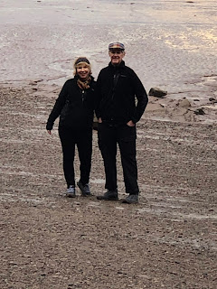
Deb and Ed, the only life that can be found among the mud and rocks.
Scads of park officials roam the beach aiding, informing, and protecting visitors.
Water hoses are provided to wash the mud from shoes.
The toadstools are five or six times the height of a normal Bunny.
Nine German families sailed up this river in 1765 to settle in what's now Moncton. They formed a communal farm at first, sharing the work, the livestock, and the shelter. Eventually, each family was issued a land grant of around 2,000 acres. Descendants of the original settlers still reside in the community.
The tide waters, ever churning either in or out, provide a powerful carving force.
Notice the green around the bases, marking the minimum height of the high tide.
The force of the water provides no purchase for marine life. Sea creatures must find other places to live.
Did someone say, "Mushrooms"?
Moncton, a bi-lingual town, welcomes both French and English.
Surfers riding the tidal bore of the muddy Petitcodiac River, also known as the Chocolate River.
These two were absolutely giddy from their surf today.


No comments:
Post a Comment